
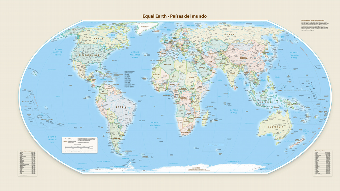
The UN, at the request of the African Union, promotes the use of a world map of proportions more faithful to reality.
“I will never forget the surprise I felt the first time I flew from Lagos to London and realized that, in a six-hour flight, four hours passed over Africa and only two over Europe.” Nigerian data analyst and geopolitics expert Cheta Nwanze argues that the Mercator projection, the most used on world maps, is not neutral: it makes Northern nations appear visually dominant. “When children grow up looking at maps that reduce Africa, they assimilate something that no textbook can easily correct: the feeling that the continent is less important and less worthy of attention,” he says in the online medium. This Day.
The map created by the Flemish cartographer Gerardus Mercator in the 16th century fulfills the objective of facilitating navigation, but does not preserve the actual proportions. It exaggerates the size of the lands near the poles, giving disproportionate visual importance to Europe, Russia and North America, and compresses the equatorial regions. Greenland, for example, appears almost as large as Africa, although it occupies about 14 times the area.
«During the “scramble for Africa”, at the end of the 19th century, the European powers divided up the continent with a confidence that bordered on recklessness. (…) It is difficult to avoid the conclusion that the visual reduction of Africa represented by the Mercator projection contributed to this arrogance,” says Nwanze, who adds that “the map gave them permission to imagine Africa as a manageable, conquerable place, a place that could be divided up in an afternoon. “This misperception has had consequences that have lasted beyond the colonial period.”
On September 4, the UN General Assembly approved resolution A/80/L.104 that promotes the use of projections that respect the real proportions of the continents, such as that of Equal Earth. Published in 2018 by cartographers Bojan Šavrić, Tom Patterson and Bernhard Jenny, it began to be used by NASA and was later promoted by the organizations Africa No Filter and Speak Up Africa through the Correct The Map initiative for use in institutions, media and schools. The campaign, backed by the African Union, was presented to the UN by Togo. “Correcting the map means recognizing that all regions of the world deserve to be represented with precision and dignity,” said Togolese Foreign Minister Robert Dussey, for whom the measure can improve the perception of Africa’s economic and strategic potential.
The resolution obtained 164 votes in favor, one against – USA. USA – and six abstentions. It is not binding. Although it does not require the use of a single projection or prohibit the Mercator projection, it does encourage governments, schools, organizations and companies to use equivalent representations. Togo announced that it will be the first to change its geography books. «Show the true size of Africa. Let the children see that this continent can house the US, China, India, Japan, Mexico and much of Europe, and still have land left over,” added Dussey.
In the image, representation of the planet proposed by Equal Earth in which the real size of all the continents can be perceived.
